Rand McNally is an API partner that provides data related to route mileage between Stops in a Load. The Rand McNally API integration works in the background with Trimble Maps to retrieve precise distance information (expressed in miles and kilometers) depending on TMS configuration.
View the total distance between Stops on the Trimble Map under the Load Tracking Log.
Setup
Use the TMS Admin to configure the Rand McNally API to pull real-time route mileage data via MileMaker.
Enter Credentials
Enable the Rand McNally integration by completing the following steps:
Navigate to TMS Admin.
Select Credentials.
Select the Global Services tab.
Search or locate Rand McNally in the list and open the card.
Check the Enabled box.
Enter the User ID and Password1 into the text field.
Click the Save button when finished.
Valid credentials are required from a Rand McNally subscription. See examples in the table below.
User ID | Password 1 | Password 2 | Customer Number |
|---|---|---|---|
Example: 123456 |
Example: iKndyjn8&%vjod |
Warning: The User ID and Password 1 values must match the values provided by Rand McNally. Any removed or inaccurate characters causes an error to appear in the Load Lightning Record Page (LRP) when retrieving or refreshing route data.
Remote Site Settings
Configure the Remote Site Settings for the Rand McNally integration URL and ensure these settings are updated.
Click the Setup Gear icon in the top right corner.
From the drop-down, click Setup.
In the Quick Find Toolbar, type Remote Site Settings and click the link.
From the list of remote sites, find Rand McNally and click the Edit link.
Confirm the Remote Site URL matches the Service URL.
When testing in a sandbox, confirm the Remote Site URL matches the Test Service URL.
Service URL:
https://milemaker.randmcnally.com/Api/MileMakerService/MileMaker.svcTest Service URL:
https://milemaker.randmcnally.com/Api/MileMakerService/MileMaker.svcTransportation Profile
Configure the mileage version and routing preferences on the Customer Transportation Profile. The below field is only field that triggers a request to Rand McNally:
Mileage API: Set the Mileage API for each customer.
Options include Rand McNally, PC Miler, or None.
Note the following fields under the Customer Mileage & Routing section in the Customer Transportation Profile are:
Mileage API Routing
Mileage API Toll Roads*
Mileage API Borders
Mileage API Version
Mileage API Highway Only
Mileage API Override Restrictions
Although these fields can be edited, they are not read or parsed by Rand McNally. Edit the page by clicking the pencil icon on the right side of the Customer Transportation Profile to hide these fields in the UI.
*Note: If there is a toll road route option between Stops, Rand McNally provides this information in the API response. This field is not stored in the TMS and does not impact routing.
Load Map
The Rand McNally integration does not support the Route Options feature on the Load Map component.
However, Rand McNally supports two other Load Map options that can be enabled or disabled:
Refresh map
Hide Weather
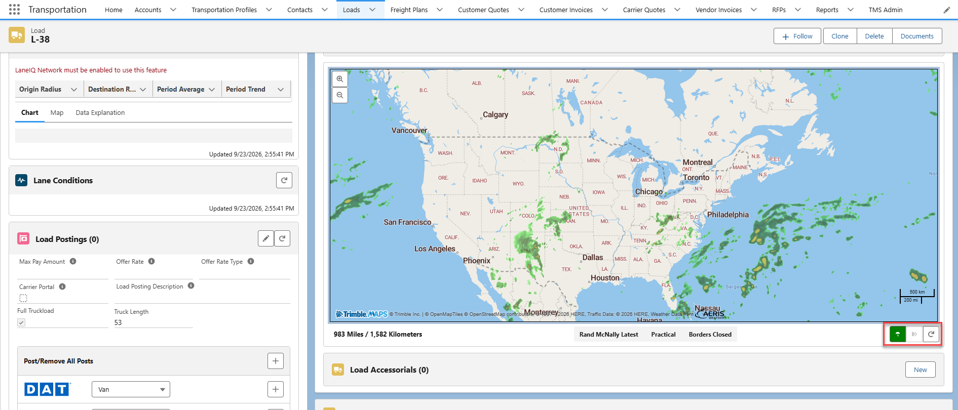
Refresh Route
Note: The map displayed in the component is provided via the Trimble Map integration. Refreshing the Trimble Map is not the same as refreshing the route. Refreshing the Trimble Map only updates the map; whereas, refreshing the route updates the Stops and the map.
Select the Refresh Route button  in the Load Detail LWC to update the mileage information and the Load Map using the Rand McNally integration.
Integration Calls
The Rand McNally API integration makes two different requests via the MileMaker endpoint:
Although both API requests respond differently, the Validate Mileage Operation and Get Mileage Operation work in tandem and cannot be requested separately.
In the TMS, users trigger both requests simultaneously by:
Creating or updating a Stop. Creating Stops via the Load Configuration LWC or editing Stops/clicking the Refresh Route button in the Load Detail.
Requesting Carrier Status update. Clicking the Request Carrier Status button in the Load Lightning Record Page (LRP).
Validate Operation
The Validate Operation is the first step in ensuring the Stop location/address data from MileMaker is accurate. The Validate Operation confirms a location match and any adjacent locations that may also match. The TMS sends location information as URL parameters to determine if location data is valid.
Locations accepted by Rand McNally include the following.
City, State
City, Count Qualifier, State
Latitude/Longitude
ZIP Code
3-digit ZIP code
Rand McNally recognizes two-part city names and Canadian zip codes normally regardless of space between entered values.
Request Operation | Rand McNally/MileMaker Endpoint | Request Type | Response |
|---|---|---|---|
| Receives locations that match or closely match location data provided. | GET | 200: SUCCESS |
Note: The Validate Operation produces a FAILURE code for two reasons:
The User ID and Password 1 fields do not match the correct Rand McNally credentials.
The Account associated with the Customer Transportation Profile does not have a complete address (for example, no city or zip code values).
Base URL for the GET Validate request.
https://milemaker.randmcnally.com/Api/MileMakerService/MileMaker.svc/Validate?location=Lebanon,OH&zipflag=0No TMS fields are included in the GET Validate request.
Sample GET Validate response payload.
No TMS fields are updated from the GET Validate response payload.
{
  "ValidateResult": {
    "Response": {
      "Status": "SUCCESS",
      "ValidatedRecord": [
        {
          "f1_City": "LEBANON",
          "f2_County": "MO",
          "f3_State": "OH",
          "f4_Latitude": "39.616245",
          "f5_Longitude": "-81.27402",
          "f6_FullCounty": "MONROE",
          "f8_Country": "US"
        },
        {
          "f1_City": "LEBANON",
          "f2_County": "WA",
          "f3_State": "OH",
          "f4_Latitude": "39.433376",
          "f5_Longitude": "-84.20846",
          "f6_FullCounty": "WARREN",
          "f8_Country": "US"
        },
        {
          "f1_City": "LEBANON JCT",
          "f2_County": "",
          "f3_State": "OH",
          "f4_Latitude": "39.77",
          "f5_Longitude": "-84.18",
          "f6_FullCounty": "MONTGOMERY",
          "f8_Country": "US"
        },
        {
          "f1_City": "LENOX",
          "f2_County": "",
          "f3_State": "OH",
          "f4_Latitude": "41.68354",
          "f5_Longitude": "-80.78114",
          "f6_FullCounty": "ASHTABULA",
          "f8_Country": "US"
        },
        {
          "f1_City": "LERADO",
          "f2_County": "",
          "f3_State": "OH",
          "f4_Latitude": "39.17473",
          "f5_Longitude": "-84.0083",
          "f6_FullCounty": "CLERMONT",
          "f8_Country": "US"
        },
        {
          "f1_City": "LEO",
          "f2_County": "",
          "f3_State": "OH",
          "f4_Latitude": "39.14805",
          "f5_Longitude": "-82.6692",
          "f6_FullCounty": "JACKSON",
          "f8_Country": "US"
        },
        {
          "f1_City": "LEVANNA",
          "f2_County": "",
          "f3_State": "OH",
          "f4_Latitude": "38.766567",
          "f5_Longitude": "-83.88373",
          "f6_FullCounty": "BROWN",
          "f8_Country": "US"
        },
        {
          "f1_City": "LEROY",
          "f2_County": "",
          "f3_State": "OH",
          "f4_Latitude": "41.025997",
          "f5_Longitude": "-81.9332",
          "f6_FullCounty": "MEDINA",
          "f8_Country": "US"
        },
        {
          "f1_City": "LENA",
          "f2_County": "",
          "f3_State": "OH",
          "f4_Latitude": "40.14029",
          "f5_Longitude": "-84.027245",
          "f6_FullCounty": "MIAMI",
          "f8_Country": "US"
        },
        {
          "f1_City": "LEON",
          "f2_County": "",
          "f3_State": "OH",
          "f4_Latitude": "41.653606",
          "f5_Longitude": "-80.6161",
          "f6_FullCounty": "ASHTABULA",
          "f8_Country": "US"
        },
        {
          "f1_City": "LEAPER",
          "f2_County": "",
          "f3_State": "OH",
          "f4_Latitude": "38.68223",
          "f5_Longitude": "-82.2703",
          "f6_FullCounty": "GALLIA",
          "f8_Country": "US"
        },
        {
          "f1_City": "LEAVITTSVILLE",
          "f2_County": "",
          "f3_State": "OH",
          "f4_Latitude": "40.513607",
          "f5_Longitude": "-81.1964",
          "f6_FullCounty": "CARROLL",
          "f8_Country": "US"
        },
        {
          "f1_City": "LAWCO",
          "f2_County": "",
          "f3_State": "OH",
          "f4_Latitude": "38.63944",
          "f5_Longitude": "-82.7022",
          "f6_FullCounty": "LAWRENCE",
          "f8_Country": "US"
        },
        {
          "f1_City": "LECTA",
          "f2_County": "",
          "f3_State": "OH",
          "f4_Latitude": "38.674973",
          "f5_Longitude": "-82.37665",
          "f6_FullCounty": "LAWRENCE",
          "f8_Country": "US"
        },
        {
          "f1_City": "LETART FLS",
          "f2_County": "",
          "f3_State": "OH",
          "f4_Latitude": "38.893105",
          "f5_Longitude": "-81.92433",
          "f6_FullCounty": "MEIGS",
          "f8_Country": "US"
        },
        {
          "f1_City": "LE SOURDSVILLE",
          "f2_County": "",
          "f3_State": "OH",
          "f4_Latitude": "39.441128",
          "f5_Longitude": "-84.429985",
          "f6_FullCounty": "BUTLER",
          "f8_Country": "US"
        },
        {
          "f1_City": "LEETONIA",
          "f2_County": "",
          "f3_State": "OH",
          "f4_Latitude": "40.87539",
          "f5_Longitude": "-80.75591",
          "f6_FullCounty": "COLUMBIANA",
          "f8_Country": "US"
        },
        {
          "f1_City": "LATHROP",
          "f2_County": "",
          "f3_State": "OH",
          "f4_Latitude": "39.44",
          "f5_Longitude": "-81.91",
          "f6_FullCounty": "ATHENS",
          "f8_Country": "US"
        },
        {
          "f1_City": "LEESBURG",
          "f2_County": "",
          "f3_State": "OH",
          "f4_Latitude": "39.345127",
          "f5_Longitude": "-83.55476",
          "f6_FullCounty": "HIGHLAND",
          "f8_Country": "US"
        },
        {
          "f1_City": "LAUGHLIN",
          "f2_County": "",
          "f3_State": "OH",
          "f4_Latitude": "40.62",
          "f5_Longitude": "-80.58",
          "f6_FullCounty": "COLUMBIANA",
          "f8_Country": "US"
        },
        {
          "f1_City": "LAYMAN",
          "f2_County": "",
          "f3_State": "OH",
          "f4_Latitude": "39.403255",
          "f5_Longitude": "-81.72451",
          "f6_FullCounty": "WASHINGTON",
          "f8_Country": "US"
        },
        {
          "f1_City": "LE MOYNE",
          "f2_County": "",
          "f3_State": "OH",
          "f4_Latitude": "41.5",
          "f5_Longitude": "-83.47",
          "f6_FullCounty": "WOOD",
          "f8_Country": "US"
        },
        {
          "f1_City": "LEMOYNE",
          "f2_County": "",
          "f3_State": "OH",
          "f4_Latitude": "41.495422",
          "f5_Longitude": "-83.47328",
          "f6_FullCounty": "WOOD",
          "f8_Country": "US"
        },
        {
          "f1_City": "LAYLAND",
          "f2_County": "",
          "f3_State": "OH",
          "f4_Latitude": "40.43568",
          "f5_Longitude": "-81.96707",
          "f6_FullCounty": "COSHOCTON",
          "f8_Country": "US"
        },
        {
          "f1_City": "LEAVITTSBURG",
          "f2_County": "",
          "f3_State": "OH",
          "f4_Latitude": "41.24031",
          "f5_Longitude": "-80.8885",
          "f6_FullCounty": "TRUMBULL",
          "f8_Country": "US"
        },
        {
          "f1_City": "LEES CRK",
          "f2_County": "",
          "f3_State": "OH",
          "f4_Latitude": "39.42028",
          "f5_Longitude": "-83.649376",
          "f6_FullCounty": "CLINTON",
          "f8_Country": "US"
        },
        {
          "f1_City": "LEESVILLE",
          "f2_County": "CA",
          "f3_State": "OH",
          "f4_Latitude": "40.45172",
          "f5_Longitude": "-81.21225",
          "f6_FullCounty": "CARROLL",
          "f8_Country": "US"
        },
        {
          "f1_City": "LEESVILLE",
          "f2_County": "CR",
          "f3_State": "OH",
          "f4_Latitude": "40.8",
          "f5_Longitude": "-82.79",
          "f6_FullCounty": "CRAWFORD",
          "f8_Country": "US"
        },
        {
          "f1_City": "LEESVILLE XRD",
          "f2_County": "",
          "f3_State": "OH",
          "f4_Latitude": "40.795483",
          "f5_Longitude": "-82.78844",
          "f6_FullCounty": "CRAWFORD",
          "f8_Country": "US"
        },
        {
          "f1_City": "LEIPSIC",
          "f2_County": "",
          "f3_State": "OH",
          "f4_Latitude": "41.09843",
          "f5_Longitude": "-83.98438",
          "f6_FullCounty": "PUTNAM",
          "f8_Country": "US"
        },
        {
          "f1_City": "LEIPSIC JCT",
          "f2_County": "",
          "f3_State": "OH",
          "f4_Latitude": "41.11",
          "f5_Longitude": "-83.98",
          "f6_FullCounty": "PUTNAM",
          "f8_Country": "US"
        },
        {
          "f1_City": "LEISTVILLE",
          "f2_County": "",
          "f3_State": "OH",
          "f4_Latitude": "39.53252",
          "f5_Longitude": "-82.84084",
          "f6_FullCounty": "PICKAWAY",
          "f8_Country": "US"
        },
        {
          "f1_City": "LEITH",
          "f2_County": "",
          "f3_State": "OH",
          "f4_Latitude": "39.46",
          "f5_Longitude": "-81.15",
          "f6_FullCounty": "WASHINGTON",
          "f8_Country": "US"
        },
        {
          "f1_City": "LEMERT",
          "f2_County": "",
          "f3_State": "OH",
          "f4_Latitude": "40.89416",
          "f5_Longitude": "-83.0936",
          "f6_FullCounty": "CRAWFORD",
          "f8_Country": "US"
        },
        {
          "f1_City": "LEONARDSBURG",
          "f2_County": "",
          "f3_State": "OH",
          "f4_Latitude": "40.357086",
          "f5_Longitude": "-82.98916",
          "f6_FullCounty": "DELAWARE",
          "f8_Country": "US"
        },
        {
          "f1_City": "LESTER",
          "f2_County": "",
          "f3_State": "OH",
          "f4_Latitude": "41.180748",
          "f5_Longitude": "-81.93781",
          "f6_FullCounty": "MEDINA",
          "f8_Country": "US"
        },
        {
          "f1_City": "LATHAM",
          "f2_County": "",
          "f3_State": "OH",
          "f4_Latitude": "39.098877",
          "f5_Longitude": "-83.24651",
          "f6_FullCounty": "PIKE",
          "f8_Country": "US"
        },
        {
          "f1_City": "LATTY",
          "f2_County": "",
          "f3_State": "OH",
          "f4_Latitude": "41.091633",
          "f5_Longitude": "-84.573425",
          "f6_FullCounty": "PAULDING",
          "f8_Country": "US"
        },
        {
          "f1_City": "LAUB FOOD MRT 3",
          "f2_County": "",
          "f3_State": "OH",
          "f4_Latitude": "41.50502",
          "f5_Longitude": "-84.3064",
          "f6_FullCounty": "FULTON",
          "f8_Country": "US"
        },
        {
          "f1_City": "LAURA",
          "f2_County": "",
          "f3_State": "OH",
          "f4_Latitude": "39.99668",
          "f5_Longitude": "-84.40865",
          "f6_FullCounty": "MIAMI",
          "f8_Country": "US"
        },
        {
          "f1_City": "LAYHIGH",
          "f2_County": "",
          "f3_State": "OH",
          "f4_Latitude": "39.362545",
          "f5_Longitude": "-84.69624",
          "f6_FullCounty": "BUTLER",
          "f8_Country": "US"
        },
        {
          "f1_City": "LAWRENCE",
          "f2_County": "",
          "f3_State": "OH",
          "f4_Latitude": "38.645",
          "f5_Longitude": "-82.6736",
          "f6_FullCounty": "LAWRENCE",
          "f8_Country": "US"
        },
        {
          "f1_City": "LAWRENCEVILLE",
          "f2_County": "",
          "f3_State": "OH",
          "f4_Latitude": "39.98554",
          "f5_Longitude": "-83.879486",
          "f6_FullCounty": "CLARK",
          "f8_Country": "US"
        },
        {
          "f1_City": "LATTASVILLE",
          "f2_County": "",
          "f3_State": "OH",
          "f4_Latitude": "39.35",
          "f5_Longitude": "-83.21",
          "f6_FullCounty": "ROSS",
          "f8_Country": "US"
        },
        {
          "f1_City": "LAWNDALE",
          "f2_County": "",
          "f3_State": "OH",
          "f4_Latitude": "40.79",
          "f5_Longitude": "-81.54",
          "f6_FullCounty": "STARK",
          "f8_Country": "US"
        },
        {
          "f1_City": "LAWSHE",
          "f2_County": "",
          "f3_State": "OH",
          "f4_Latitude": "38.94055",
          "f5_Longitude": "-83.469696",
          "f6_FullCounty": "ADAMS",
          "f8_Country": "US"
        },
        {
          "f1_City": "LATIMER",
          "f2_County": "",
          "f3_State": "OH",
          "f4_Latitude": "41.35667",
          "f5_Longitude": "-80.618095",
          "f6_FullCounty": "TRUMBULL",
          "f8_Country": "US"
        },
        {
          "f1_City": "LAUREL",
          "f2_County": "",
          "f3_State": "OH",
          "f4_Latitude": "38.91556",
          "f5_Longitude": "-84.19109",
          "f6_FullCounty": "CLERMONT",
          "f8_Country": "US"
        },
        {
          "f1_City": "LATTASBURG",
          "f2_County": "",
          "f3_State": "OH",
          "f4_Latitude": "40.87899",
          "f5_Longitude": "-82.108315",
          "f6_FullCounty": "WAYNE",
          "f8_Country": "US"
        },
        {
          "f1_City": "LAURELVILLE",
          "f2_County": "",
          "f3_State": "OH",
          "f4_Latitude": "39.47288",
          "f5_Longitude": "-82.73919",
          "f6_FullCounty": "HOCKING",
          "f8_Country": "US"
        }
      ]
    }
  }
}
Get Mileage Operation
The Get Mileage Operation is the final step in retrieving the routing distance data from MileMaker. The TMS sends location information as URL parameters to determine the distance between points.
Locations accepted by Rand McNally include the following.
City, State
Address, City, State
City, Count Qualifier, State
Latitude/Longitude
ZIP Code
3-digit ZIP code
TMS Operation | Rand McNally Endpoint | Request Type | Response |
|---|---|---|---|
| Receives updated route mileage data from MileMaker. | GET | 200: SUCCESS 400: FAILURE |
Sample base URL for the GET Mileage request.
https://milemaker.randmcnally.com/Api/MileMakerService/MileMaker.svc/Mileage?routetype=P&location1=Brookfield,OH&Location2=Bannockburn,IL&Location3=Houston,TX&Location4=Boston,MA&trucklength=53&hazmat=0&kmflag=0&avoidtolls=0Sample GET Mileage response payload with a 200: SUCCESS.
{
  "MileageResult": {
    "Response": {
      "Status": "SUCCESS",
      "MileageRecord": [
        {
          "f1_Location": "Total",
          "f2_Miles": "3401",
          "f3_TollCostUSA": "383.27",
          "f4_TollCostCN": "0.00",
          "f5_Time": "57:17",
          "f6_County": ""
        },
        {
          "f1_Location": "BROOKFIELD,OH",
          "f2_Miles": "",
          "f3_TollCostUSA": "",
          "f4_TollCostCN": "",
          "f5_Time": "",
          "f6_County": "TRUMBULL"
        },
        {
          "f1_Location": "BANNOCKBURN,IL",
          "f2_Miles": "432",
          "f3_TollCostUSA": "176.85",
          "f4_TollCostCN": "0.00",
          "f5_Time": "8:11",
          "f6_County": "LAKE"
        },
        {
          "f1_Location": "HOUSTON,TX",
          "f2_Miles": "1122",
          "f3_TollCostUSA": "40.45",
          "f4_TollCostCN": "0.00",
          "f5_Time": "19:06",
          "f6_County": "HARRIS"
        },
        {
          "f1_Location": "BOSTON,MA",
          "f2_Miles": "1847",
          "f3_TollCostUSA": "165.97",
          "f4_TollCostCN": "0.00",
          "f5_Time": "30:00",
          "f6_County": "SUFFOLK"
        }
      ]
    }
  }
}
There is one (1) field stored in the TMS after triggering the Get Mileage request:
TMS Object | TMS Field | Type | Rand McNally Field |
|---|---|---|---|
Stop | Miles Away | Number | f2_Miles |
Sample GET Mileage response payload with a 400: FAILURE.
{
  "errors": {
    "location": [
      "The location field is required."
    ]
  },
  "type": "https://tools.ietf.org/html/rfc9110#section-15.5.1",
  "title": "One or more validation errors occurred.",
  "status": 400,
  "traceId": "00-f208d3741a0d6cc86fdc44c82daf5f8a-4eab5fefb1778bbf-01"
}
API Field Reference
TMS Object | TMS Field | Type | Rand McNally Field |
|---|---|---|---|
Stop | Miles Away | Number | f2_Miles |
